

East face of the dam
Jerry McAllister and Bob Simpson
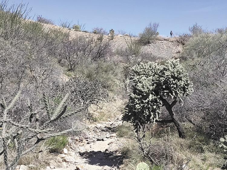
Ocotillo Canyon descends impressively and deeply, with curved embankments and some dense bottom vegetation, as it moves downward through Unit 21 to the Cañada del Oro (CDO), passing two small horse ranches on the way. Because of streetside residences, there are few viewpoints to appreciate the canyon’s beauty. One of the best is a small trail from the corner of Cañada del Oro Drive and Desert Wind Road. Following the small path down to Ocotillo Canyon Drive, most walkers are unaware that they are traversing the broad top of a small dam. However, on the east side of the trail, they can see the rock-faced downstream side of the dam and, just beyond, the buildings of Two Horse Ranch, which actually has two horses.
Off the trail’s west side, the canyon’s more impressive depth and length are seen, and the dam is more rock-faced and steep. A landmark on that side is a 2-inch water pipe standing some 8 to 10 feet high with a downward nozzle for filling truck-borne water tanks, betraying the history of the dam as a road. A buried Lago del Oro waterline traverses the dam and connects to an impressive array of large standing pipes on Ocotillo Canyon Road.
Above the dam, some homeowners’ lots extend into the canyon, but most of the interior canyon consists of SaddleBrooke One common areas (parcels A-N) conveyed by Robson Development Company on Sept. 10, 2004. These parcels are “only for Association purposes and activities.” Upstream at the intersection of Cleek Drive and Ocotillo Canyon Drive, a concrete ditch channels water down to an abutment where it pools before continuing down to the dam.
History
The area below the dam was first mined in about 1985 when Horace “Okie” Cothren operated a sand and gravel mining operation along the CDO. According to Okie’s friend Jim McGlaughlin, product was transported down the wash to the Pima County line (Edwin Road) and on to Tucson customers. Today, the old route, still dirt, is reflected on Pinal County maps as Santa Monica Trail. The postal addresses of Two Horse Ranch and Dancing Horse Ranch use that colorful name. However, while the route is historic, the name was created by Pinal County only after 2012 in connection with road easements to the county granted by private property owners.
A 1978 survey shows a road crossing Ocotillo Canyon at the dam site. Probably built by Lloyd Golder and related to his developments around Golder Dam and Lake, it would have included a culvert, possibly the one existing today. Thus, to authors Jerry and Bob, it was even then a dam. However, the State of Arizona quibbles. Finding today’s structure too small to require permits, the Department of Water Resources calls it a “non-jurisdictional embankment” with a retention capacity of only about 10 acre-feet of water (they say a jurisdictional dam would retain closer to 15). The November 2000 Watershed Delineation Map for SaddleBrooke Unit 21 does indeed show the spot as “Detention Area 40,” which collects runoff from three upstream sub-basins, metering it through a 36-inch culvert pipe.
Fine. We call it the Hidden Dam and stop there often for the views and birdsong.